
What is the atmospheric front. Atmospheric front. Warm and Cold Front Warm and Cold Atmospheric Front Geography
If sometimes huge streams of warm and cold air flows are suitable close to each other, then on the map of the weather between them you can spend a clear line of the section, or as meteorologists say, the front line.
Here with such fronts, rainy weather, chained rains or snowfalls are connected.
The boundary between warm and cold air masses is a surface. This surface is almost horizontal and only slightly, completely unnoticed, lowers to the front line.
Cold air is under the front surface; It has a shape resembling the blade of the ax, and the warm air is located above this surface. Where the front surface is lowered to the earth itself, i.e., along the "ax blade", the front line passes.
Since the air masses are all the time in motion, the border between them moves in the direction of warm air, then towards the cold.
On any weather map, you can notice one very important and characteristic feature: the front line of the front is necessarily underway through the center of the lower pressure area, and, on the contrary, the fronts will never pass through the centers of the regions of the heightened pressure.
Warm front
If the front moves in the direction from warm air to the cold, that is, the cold air retreats, and warmly comes after it, then such a front is called a warm front. It is such a warm front that brings us most often the longest rains. When the warm front moves through any terrain, it comes there: the warm mass comes to change the cold air mass.
Warm air moves faster than cold, catch up with him, and he has to "climb on the back" of retreating cold air. And the rise of air leads to its cooling; Consequently, in warm air over the front surface, clouds are formed. Warm air climbs up very slowly and gradually, therefore, the cloudy of the warm front and has the kind of smooth smooth pellens of the peristo-layered and highly alone clouds. This paddle stretches along the front line with a wide band of a few hundred meters of width and sometimes thousands of kilometers in length. The further ahead from the front line there are clouds, the higher they over the ground and the thinner. The highest clouds are called pirila. They are at an altitude of 7-9 km and consist of ice crystals.
The peristo-layered clouds also consist of ice crystals, but they are located slightly lower and closer to the front. Highly block clouds are even lower - at an altitude of 2-4 m and at a distance of 100-400 km from the front. The front of the front is located layered rain clouds. Low torn clouds of "bad weather" rush over the ground at an altitude of only 100-200 m. They close the tops of the hills, the tops of the radio lane and sometimes the tops of the factory pipes.
After passing the front, the wind changes its direction, and he always turns to the right. If before the front, the wind blew from the south-east, then after passing the front, it already blows from the south; If the wind was southern, then he becomes southwestern or western.
High transparent clouds moving on 800-900 km ahead of the line of the warm front, are those expelled the "messengers" who long warn us about the attitude of bad weather. It is for their appearance for 10-14 hours ahead to predict the beginning of the rain in summer or snowfall in winter.
We looked at the formation of precipitation, which usually create long-term bad weather.
Cold front
Often a clear day is replaced by a stormy shower, thunderstorms and a squall, followed by cooling. This weather is connected to the cold front. If warm air retreats, and cold spreads after it, then such a front is called a cold front. The arrival of this front always causes cooling, as the warm air mass is replaced with cold.
The lower part of the cold front due to friction about the earth surface moves more slowly and lags behind it. Therefore, at the top, the surface of the cold front is "protruding" forward, the cold air in the "head" of the cold front is condensed down, and the front surface takes a convex shape of a rolled shaft. This shaft is moving faster than retreating warm air, cattures it and thumps him straight up straight up. A shaft of fluttering dark clouds (cumulus-rain clouds) is formed with shower, thunderstorms and hail (summer) or a snowy squall and a snowstorm (winter).
The strongest thunderstorms and squalls are always associated with the cold front.
Weather prediction
Knowing the mutual connection of weather phenomena and carefully observing its changes, you can predict the onset of bad weather or improving the weather. It is only necessary to remember that none of the signs of changing weather cannot be used separately from other weather phenomena. It is always necessary to first imagine everything that is happening at the moment in the atmosphere, and only on the basis of this you can predict the weather changes.
Any strong deterioration in the weather is due to the arrival of cyclones and related fronts, which are replaced by anticyclones, and you can trace their movement only by special synoptic maps. For local weather prediction, you can use only some signs of approaching fronts and cyclones.
In the summer, during good weather, a sign of the possible attack of bad weather will be a violation of the usual daily weather move, which is characterized by the rise in temperature and lowering it at night, the wind strengthening day and weakening at night, education in the afternoon of cumulus clouds, falling out the dew and the formation of morning fogs at night.
About the approach of the warm front, and therefore, the cyclone always says night warming. In the cyclone, the winds are usually stronger than in the anticyclone, so with the cyclone approximation, the wind is noticeably enhanced. Before the strengthening of the wind in the afternoon or too insignificant at night in a day or too insignificant at night indicates the cyclone approximation. The lack of dew and fog at night also serves as a sign of cyclone approximation. Sometimes the weak development of heap cloudiness sometimes points to the day.
In winter, the daily course of weather phenomena is expressed weakly and the approaching cyclone usually makes it possible to know about the wind boost and increase the temperature.
All these signs, even if they are sharply pronounced and are observed at the same time, they still do not give confidence in the attitude of bad weather. The most faithful signs of close bad weather are the appearance in the sky of the patch and peristo-layered clouds, which are condensed in a certain - most often in the western part of the horizon. At the same time, the wind should blow in such a way that if you become back to him, then the clouds thickening should be left and somewhat ahead - where there should be low pressure.
Signs of the termination of bad weather: a sharp cooling during rain and snow; Changing the wind direction to the North-West or Northern; changing the nature of precipitation; The transition of uniform, with a continuous cloudiness, rain in sharply changing on the power of shower, sometimes with a thunderstorm and hail, solid snowfall - in separate strong flashes of the PURGI.
Warm Front - The transition zone between the warm and cold air masses moving towards cold air. In the zone of the warm front, the warm air flows on the retreating cold air. The average speed of movement of the warm fronts is approximately 20-30 km / h. Before the warm front, the air pressure, as a rule, falls significantly over time, which can be detected according to the baric trend on the surface map of weather.
As a result of an ordered rise in warm air on the wedge of cold air on the front, a characteristic system of layered clouds is formed, which includes layered rain, highly rock and peristo-layered clouds. The system of clouds is located above the front surface in warm air in front of the surface line of the warm front.
In the direction perpendicular to the front line, the cloud system extends to a distance of several hundred kilometers. The zone of front rainfall dropping out of layered clouds has a smaller width than the cloud zone. Under the front surface in the wedge of cold air, where slavement precipitates occurs, there are low torn-rain clouds, the height of the lower boundary of which can be below 200 m.
If a typical warm front is approaching to the airfield, then the Cirrus Uncinus, CI UNC is first appear (Cirrus Uncinus, Ci Unc.) Clouds - forerunners of a warm front. Then there are peristo-layered clouds covering the entire occasion in the form of a light white veil.
Then high-alone clouds appear in the sky. Gradually, the lower boundary of the layered cloudiness is lowered, the power of the clouds increases, layered-rain clouds appear, of which there are chain precipitates. The sun and the moon become invisible. From highly alone clouds, precipitation can only fall out during the cold period of the year, and in the warm period of precipitation from these clouds, as a rule, do not reach the ground surface, evaporating on the way to it.
The area of \u200b\u200bchain precipitation is usually ahead of the surface line of the warm front in the wedge of cold air.
In the warm period of the year on a warm front with an unstable stratification of the atmosphere, heap-rain clouds with rains, hail, thunderstorms, with which strong wind shifts are associated, strong turbulence and strong icing of aircraft may occur. Kuch-rain clouds in the system of layered clouds are visually difficult to detect, so these clouds are called disguised.
Cold fronts, their features, clouds.
Cold front - The transition zone between warm and cold air masses, which moves toward warm air. Behind the cold front, the air pressure is usually growing significantly over time, which can be detected by a barytic trend on the surface cards of the weather. The angle of inclination of cold fronts is usually more than warm fronts.
Depending on the speed of movement and characteristic cloudiness, the cold fronts of the first and second kind are distinguished. The speed of the cold front of the first kind on average is 30-40 km / h. The cold front of the second kind is a fast moving front, shifts at a speed of 50 km / h or more.
The system of clouds of the cold front of the first kind differs significantly from the cloudiness of the cold edge of the second kind.
Clouds cold Front of the first kind Like clouds of a warm front, but they are located in reverse order with respect to the surface line of the front, compared with the clouds of a warm front. Behind the line of the typical cold front of the first kind, there is a layered cloudiness and zone of chain precipitation: they first observe layered and rain clouds, then follow high-aluminous and peristo-layered clouds.
The width of the cloud system in the direction perpendicular to the front line, in the case of a cold front of the first kind, it is usually smaller than in the case of a warm front. In the warm period on the cold front of the first kind, heap-rain clouds with rains, thunderstorms, squalls are often formed.
Cold Front of the Second Rod It is the most dangerous for aviation from all types of fronts. For this front, typical is a cumulating clouds, which is formed along the front line of the front as a narrow strip. The width of the cloud zone in the direction perpendicular to the front line, the average is several tens of kilometers. The same width has a zone of storm sediments. When blurring cumulus-rain clouds, all forms of clouds can be observed, except layered and cumulus clouds.
The formation of cumulating-rain clouds in the zone of the cold front of the second kind is due to the forced convection in the form of strong ascending flows for warm air. The upper part of the brown clouds in the form of an anvil consisting mainly of the peristo-layered clouds is pulled in direction of the movement of the front.
The harbingers of the Cold Front of the second kind are high-tech lentilscence clouds that appear ahead of the front line at a distance of about 100-200 km. The passage of the cold edge of the second kind is often accompanied by strong shoes, squalls, thunderstorms, hail, sometimes silence, dust or sandy storms.
Cold fronts are particularly dangerous for aircraft flying in summer in the afternoon, when the maximum heating of the underlying surface is observed. At this time, the likelihood of meteorological phenomena dangerous for aircraft, which is rarely clouded, increases significantly.
Fronts occlusion.
Front occlusion (from lat. Occlusus - closure) - a complex front, formed as a result of a closure of cold and warm fronts. The cold front moves with greater speed than warm. Therefore, in the end, he catches the warm front and closes with him.
Warm front occlusion Or the front of occlusion in the type of the warm front is characterized by the fact that the air mass at the front of the occlusion is more warm than the air mass in front of the occlusion front.
Cold front occlusion Or the front of occlusion in the type of cold front is characterized by the fact that the air mass at the front of the occlusion is colder than the air mass in front of the occlusion front.
The air mass at the front of the occlusion is the air mass that was observed in the cold front before it was closed with a warm front. The air mass in front of the occlusion front is the air mass that was observed before the warm front before the process of formation of occlusion began.
On average, for the year, the cold fronts of occlusion are noted more often than the warm fronts of occlusion. Over the continent, the warm front of the occlusion is more often observed in winter than in summer, and the cold front occlusion is more often observed in summer than in winter.
In the case of a warm front of occlusion, the surface of the occlusion is part of the surface of the warm front, and in the case of a cold front of the occlusion, the surface of the occlusion is part of the surface of the cold front.
Cloudiness and precipitation of the occlusion front are the result of combining cloud systems and rainfall warm and cold fronts. Usually, the more the duration of the occlusion front existence, the greater thickness have cloudless interlayers and the less dangerous is the front of occlusion for aircraft flights.
Stages of development of cyclones.
Cyclone passes four stages of development.
The first stage of the cyclone development - stage of Wave, Cyclone in this stage is called wave. Wave cyclone - low bary formation. The wave stage continues for several hours - from the occurrence of wave perturbation on the atmospheric front before the appearance of the first closed isobara, a multiple 5 GPa, on the surface map of the weather. The wave oscillations on the front occur under the influence of a number of factors, the main of which are the differences in the front of the air in the density of air and the speed of movement.
The wave cyclone deepens and moves into the second stage of its development - stage of young cyclone. When deepening cyclone, air pressure in its center decreases over time. Young cyclone is a secondary bary formation (2-7 km). The stage of the young cyclone lasts from the moment of the appearance of the first closed isobar on the surface map of the weather before the process of occluding cyclone.
Cyclone occlusion - the formation of an occlusion front.
In the young cyclone, three parts differ in the weather, differing on weather conditions: the front, rear and warm sector. When the cyclone is removed from the center, the power of the clouds and the intensity of precipitation decrease in all parts of the cyclone.
the front of The cyclone is located in front of a warm front, which determines the weather conditions in this part. Here are observed, as a rule, layered clouds.
Rear part The cyclone is behind the cold front. Therefore, its meteorological conditions are determined by the properties of the cold front and in the front of the cold air mass.
Warm sector The cyclone is located between the warm and cold fronts. In the warm sector dominates a warm air mass.
A young cyclone with circular source, as a rule, is mixed towards the isobar of its warm sector.
The third stage of the development of the cyclone - stage of maximum development, lasts from the start of the cyclone occluding before filling it. When filling the cyclone, the air pressure in its center is growing over time. The most developed cyclone, compared with other stages:
Reaches the greatest depth, there is a smallest air pressure in the center of the cyclone;
It takes the largest area, on the surface map of the weather in the cyclone, the largest number of closed isobar is carried out;
It is characterized by the greatest area of \u200b\u200bclouds and atmospheric precipitation.
Point of occlusion in cyclone - This is a point on the surface map of the weather, where three fronts are closed: warm, cold and front occlusion. The most developed cyclone is an occluded, high and shifted slower than a young cyclone.
The fourth stage of the development of the cyclone - stage of filling cyclone, lasts from the beginning of the filling of the cyclone until the closed isobar is disappeared on the weather map, i.e. Before the disappearance of the cyclone. This stage is the longest of all stages and can last a few days.
Filled cyclone - occluded, cold, sedentary, high barical education. Clouds in this stage are gradually blurred, the precipitation is stopped.
It turned out that the warm air is delayed in the cyclone not throughout its oriental (right) half, but in a fairly limited sector, located in the southern and southeastern parts of the cyclone between the two lines of convergence. Cloudy and precipitation are unevenly distributed in cyclone. Cover rains fall predominantly before the first (eastern) line of the convergence of air flows, as well as in the center of the cyclone. Storm rains and thunderstorms focused in a narrow strip along the second (western) line of convergence. These lines were subsequently called atmospheric fronts. Since in moderate latitudes, cyclones are usually moved from the west to the East, through the observation item first passes the eastern front of the cyclone, followed by warm air. This atmospheric front was called warm. In the vicinity of the warm atmospheric front, warm air actively occurs on the front line, moving almost perpendicular to it, and the cold air is transferred almost in parallel to this line, i.e. Slowly retreats from it. Consequently, the warm air mass catches and distinguishes cold. Then the western (cold) front of the cyclone is approaching the observation, when the air temperature drops sharply. Near the cold atmospheric front of the dynamics: Cold air catches warm and rapidly displaces it up.
Ascending slide covers powerful layers of warm air over the entire front surface and an extensive high-layered system occurs - layered rain-rain clouds with plated precipitation. The warm front has an anticyclonic curvature and moves towards cold air. On the weather map, the warm front is marked in red or shredded semicircles directed towards the movement of the front (Fig. 1). As the line of the warm front approaches, the pressure begins to fall, clouds are compacted, covered precipitated precipitates. In winter, low layered clouds usually appear during the front. The temperature and humidity of the air are slowly rising. When the front is passed, the temperature and humidity usually increase quickly, the wind is intensified. After passing the front, the direction of the wind is changing (the wind turns clockwise), the speed decreases, the pressure drop is stopped and its weak growth begins, the clouds are dispersed, the precipitates are terminated. The field of baric tendencies is presented as follows: a closed area of \u200b\u200bpressure drop is located before the warm front, behind the front or pressure growth, or relative growth (fall, but less than before the front). The passage of a warm front is usually accompanied by a powerful layered rain, tightening all the sky, cloudy with a chain rain. The first Bulletin of the warm front is the filament clouds. Gradually, they turn into a solid white veil into peristosloy clouds. In the upper layers of the atmosphere, warm air is already moving. Pressure drops. The closer to us the front line, the denser the clouds are. The sun shines dim spot. The clouds are then lowered below, the sun is hidden at all. The wind is intensified and changes its direction clockwise (for example, first was the eastern, then southeast and even south-west) approximately 300-400 km to the cloud front are condensed. Stands small rain or snow. But the warm front passed. Rain or snow stopped, clouds dissipated, warming occurs - a warmer air mass arrived. The warm front in the vertical section is presented in fig. 2.

If warm air retreats, and the cold spread after it means it is approaching the cold front. His arrival always causes cooling. But when moving, not all air layers have the same speed. The lowest layer as a result of friction about the earth's surface is slightly delayed, and the highest pulls forward. Thus, the cold air fell on the warm in the form of a shaft. Warm air quickly displaces upwards, and powerful heaps of cumulus and cumulating rain clouds are created. The clouds of the cold front are livne, thunderstorms, accompanied by a strong impaired wind. They can achieve a very large height, but in the horizontal direction extend only 20 ... 30 km. And since the cold front is usually moving quickly, then the turbulent weather continues not long - from 15 ... 20 min. Up to 2 ... 3 hours. As a result of the interaction of cold air with a warm undercut surface, cumulus clouds with lumens are formed. Then comes a complete clarification.
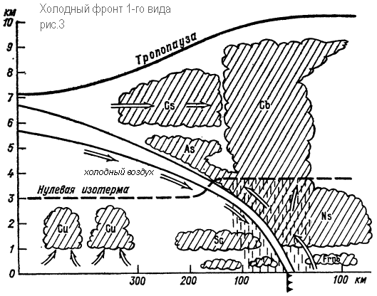
In the case of a cold front, the ascending movement of warm air is limited to a narrower zone and especially in front of the cold wedge, where the warm air is displaced cold. The clouds here will largely have the character of cumulating rainies with storm sediments and thunderstorms (Fig. 3, Fig. 4). The cold front has a cyclonic curvature (bulging toward warm air) and moves toward warm air. On the weather map, the Cold Front is marked in blue or shredded triangles directed towards the movement of the front (Fig. 1). Cold air has a component directed to the front line, so cold air, moving forward, occupies a space where it was warm to the air, which increases its instability.
When moving through a line of a warm front, the wind, as in the case of a warm front, turns to the right, but the turn is more significant and sharp - from the southwestern, southern (front) to the Western, North-Western (behind the front). This increases wind speed. Atmospheric pressure before the front changes slowly. It may fall, but can grow. With the passage of the cold front, a rapid increase in pressure begins. During the cold front there is a closed izallobaric pressure growth area, and the growth can reach 3-5 GPa / 3h. Changing the pressure towards its growth (from falling to growth, from slow growth to stronger) indicates the passage of the line of the surface front.
Before the front, thunderstorms and squalls are often observed. The air temperature after the front is dropped, and often quickly and sharply - at 10 ° C and more in 1-2 hours. The mass fraction of water vapor decreases simultaneously with the air temperature. Visibility, as a rule, is improved, because the polar or Arctic air invades the cold front. In addition, the instability of the air mass prevents condensation near the surface of the Earth.
The nature of the weather on the cold front differs significantly depending on the speed of the front of the front, the properties of warm air in front of the front, the nature of the rising movements of warm air over the wedge of cold. On the cold fronts of the 1st genus, an ordered raising of warm air over the wedge of cold air is dominated. The cold front of the 1st genus is the passive surface of the ascending slip. This type includes slowly moving or slowing down fronts, mainly on the periphery of cyclonic areas in deep baric hollows. At the same time, clouds are mainly located behind the front line. The difference from the cloudiness of the warm front still exists. Due to friction, the surface of the cold front in the lower layers becomes steep. Therefore, in front of the front line itself, instead of a calm and gentle-rising sliding, the coolest (convective) rise of warm air is observed (Fig. 3). Thanks to this, in the front of the cloud system, there are sometimes powerful cumulus and cumulus-rain clouds, stretched for hundreds of kilometers along the front, with rains in summer, snowfall in winter, thunderstorms, hail and squalls. Above the overlying part of the front surface with a normal inclination as a result of an upward slip of warm air, a cloud system represents uniform intercourse of layered clouds. Storm sediments in front of the front after passing the front are replaced by more uniform with plates. Finally, there are peristo-layered and pasty clouds. The vertical power of the system and the width of the cloud system and the area of \u200b\u200bprecipitation will be almost 2 times less than in the case of a warm front. The upper limit of the system is approximately at an altitude of 4-4.5 km. Under the main cloud system, layered torn clouds may occur, sometimes the front fogs are formed. The duration of the cold front of the 1st genus through the observation point is 10 hours and more.
The fronts of the 2nd genus in the lower layer of the atmosphere are the passive surface of the ascending slip, and above the active surface of the downward slip. This type owns most of the fast moving cold fronts in cyclones. A warm air of the bottom layers upstream is molded here by a cold shaft moving forward. The surface of the cold front in the lower layers is located very cool, forming even the bulge in the form of a shaft (Fig. 4). The rapid movement of the cold air wedge causes a forced convection of displaced warm air in a narrow space in front of the front surface. A powerful convective stream is created here with the formation of a heap-rain cloudiness, amplifying as a result of thermal convection. The forelocks of the front are highly teaching lentil clouds that apply to it to remove up to 200 km. The resulting cloud system has a small width (50-100 km) and is not separate convective clouds, but a continuous chain, or a cloud shaft, which can sometimes be solid. In the warm half of the year, the upper boundary of the cue-rain clouds applies to the height of the tropopause. On the cold fronts of the 2nd birth, there is an intense thunderstorm activity, shower, sometimes with hail, squalid winds. In the clouds, a strong bolt and icing. The width of the zone of dangerous weather phenomena is a few tens of kilometers. In the cold half of the year, the peaks of cucco-rain clouds reach 4 km. The width of the snowfall zone is 50 km. Strong snowfalls are associated with this cloudiness, blizzards seemingly less than 1000 m, a sharp increase in wind speed, a bolt.

When the cold fronts of the 2nd kind through the observation item first (3-4 hours before the end of the front line near the Earth), there are crooked clouds that are rapidly replaced by highly precipitated, sometimes lentils, which are rapidly replaced with rains, thunderstorms, hail, squalls. The duration of moving the clouds system with storm sediments and thunderstorms usually does not exceed 1-2 hours. After passing the cold front, storm precipitations stop. A peculiarity of the cold fronts both the first and second kinds are premontal squalls. Since in the front of the cold wedge, due to friction, a steep slope of the front surface is created, part of the cold air turns out to be warm. Next occurs "collapse" down the cold air masses in the front of the moving cold shaft. The collapse of cold air leads to the ot of warm air and to the occurrence along the edge of the vortex with a horizontal axis. There are particularly intense squalls on land in summer, with a large temperature difference between the warm and cold air on both sides of the front and in the instability of warm air. Under these conditions, the passage of the cold front is accompanied by destructive wind speeds. The wind speed often exceeds 20-30 m / s, the duration of the phenomenon is usually a few minutes, sometimes impulses are observed.
Fronts occlusion
Due to the downstream movements in the cold air in the rear of the cyclone, the cold front moves faster than the warm front and with time cattons it. At the filling stage of the cyclone, complex fronts occur - the fronts of occlusion, which are formed during the closure of cold and warm atmospheric fronts.
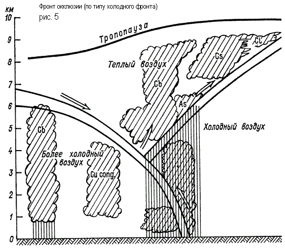
Three air masses interact in the occlusion front system, of which the warm no longer comes into contact with the surface of the Earth. The process of displacing warm air into the upper layers is called occlusion. At the same time, the rear wedge of cold air cyclone is closed with the front wedge of cold air. Warm air in the form of a funnel gradually rises up, and its place occupies cold air coming from the sides (Fig. 5). The surface of the section arising from closure of cold and warm fronts is called the surface of the occlusion front.
In the case of a cold front occlusion, precipitation can fall out on both sides of the lower front, and the transition from the chain precipitates to the storm, if it takes place, does not occur ahead of the lower front, and in close proximity to it. In the case of a warm front of occlusion, the funnel of warm air is supplanted with a warm air flowing on a wedge of colder air. The rear wedge is less cold air, cattures the front wedge of colder air, and the cold front, separated from the ground surface, rises along the surface of the warm front.
The weak upward slip of the rear air on the front along the surface of the occlusion can lead to the formation of a ST-SC clouds along it, not reaching the level of ice cores. Of them before the bottom warm front will fall out frosting precipitation.
The warm front is the moving section between the impending warm and retreating cold air.
As is known, the front surface, like the front line itself, under the "pressure" of the masses of warm air moves towards cold air. Warm air, as easier, flows a clip of the cold, while performing a gradual forced lifting along the entire frontal surface. Lifting, it is adiabatically cooled, as a result of which the water vapors available in it condense and form a cloud system. In the immediate vicinity of the front line, where the rise of warm air occurs along the coolest part of the front surface, low layered rain clouds (N8) are formed, of which rain falls in the warm season, and in cold snow. The width of the precipitation zone in the front of the warm front varies widely, but on average it is 300-400 km.
Next, behind the zone, where the front surface becomes higher and position, layered-rain clouds are gradually moving into high-layered (AB), from which weak precipitation fall. In the summer, due to the high temperature, raindrop drops falling out of ae, they evaporate to the ground; In winter, weak snow falls.
As it is further removed from the front line, high-layered clouds have been gradually moving at high heights (SE) gradually moving at high heights, and the latter - in the filament (SI). These clouds appear at a distance of 80p-1000 km (horizontally) from the line of the warm front.
Thus, cloud systems of a warm front have a regular alternation. As the warm front is approaching this item, the clouds alternate in the following sequence: SI, CE, AB and N8.
The speed of moving the warm front is different. On average, it is 25 - 30 km / h (maximum 50-60 km / h). Since the appearance of a warm front line can reach the observation item after 20-30 CHS / and the precipitation zone - after 10-15 hours.
Behind the line of the warm front moves the masses of warm air, carrying with them and the weather characteristic of them: noticeable, and sometimes sharp warming, cessation of precipitation, the appearance of advective fogs. At the time of the front of the front, the wind changes the layer direction - from the YOU to YU and YUZ (turn to the right).
There are, however, such warm fronts (poorly pronounced), which, due to the dryness of the interacting in the front surface of the air masses of the ordinary tennophroite cloudiness, do not form and pass without noticeable change in the weather, the passage of such a warm front is limited to some increase in temperature and the change of wind direction. Weathered and dry warm fronts are most often in the southern continental districts.
Thus, warm fronts in most cases from the point of view of the fifty, they carry adverse weather: prolonged (chained) precipitation, poor visibility and possible wind increase.
As a sign of the approximation of a warm front, the above sequence in changing the cloudiness as well as a gradual drop in pressure can be set.
On the synoptic map, the warm front is indicated by the red lines of AV single-color printing-black line with oval teeth, facing the front of the front.
Weather Cold VM
Weather warm VM
Warm VM, moving into the cold area, becomes stable (coolant from a cold underlying surface). The air temperature, falling, can reach the level of condensation with the formation of hassle, fog, low layered clouds with sediments of frozen or small snowflakes.
Flight conditions in warm VM winter:
Weak and moderate icing in the clouds at negative temperatures;
Cloudless sky, good visibility on H \u003d 500-1000 m;
Weak bolt on H \u003d 500-1000 m.
In the warm season, the conditions for flights are favorable with the exception of areas with separate foci of thunderstorms.
When moving into a warmer area, the cold VM is heated from below and becomes an unstable VM. Powerful ascending air movements contribute to the formation of cue-rain clouds with storm sediments, thunderstorms.
Atmospheric front - This is a section between two air masses that differ from one of the other physical properties (temperature, pressure, density, humidity, cloudiness, precipitation, direction and wind speed). Fronts are located in two directions - by horizon and vertically
The border between the air mass horizons is called front line, The boundary between the air masses vertically - Naz. frontal zone. The front zone is always tilted toward cold air. Depending on which VM comes - warm or cold distinguishes warm TF and Cold HFfronts.
A characteristic feature of the fronts is the presence of the most dangerous (complex) meteorological conditions for flight. Frontal cloud systems are distinguished by a significant vertical and horizontal length. On the fronts in the warm season there are thunderstorms, a bolt, icing, in cold weather - fog, snowfall, low clouds.
Warm front - This is the front, which moves towards cold air, followed by warming.
 The front is connected with a powerful cloud system, consisting of peristo-layered, highly light, layered rain clouds, which are made due to the rise of warm air in the wedge of the cold. SMU at TF: Low clouds (50-200m), in front of the front of fogs, poor visibility in the area of \u200b\u200bprecipitation, icing in the clouds and precipitation, ice on Earth.
Flight conditions through TF are determined by the height of the lower and upper boundaries of the clouds, the degree of resistance of VM, the temperature distribution in the cloud layer, moisture content, terrain timber, the time of the year, and day.
1. If possible, it is less located in the zone of negative temperatures;
2. Cross the front perpendicular to its location;
3. Select a flight profile in the zone of positive temperatures, i.e. Below isotherm with 0 °, and if the total temperature zone is negative, the flight is carried out there, where the temperature is below -10 °. Flight from 0 ° to -10 ° is the most intensive icing.
When meeting with dangerous MU (thunderstorm, hail, strong icing, a strong bolt), it is necessary to return to the departure airfield or plant at the spare airfield.
- Freamed front -this section of the main front, moving the side of high temperatures, followed by cooling. Two types of cold fronts distinguish:
-Hard front front (HF-1R) - This is the front moving at a speed of 20 - 30 km / h. Cold air, leaving the wedge under warm, displaces it up, forming a cue-rain-rain clouded in front of the front, rainseed, thunderstorms. Part of the TV flows into the wedge, forming a layered shaped cloudiness behind the front, chained precipitation. Before the front, a strong bolt, behind the front is bad visibility. Flight conditions via HF -1R are similar to the conditions for the intersection of TF.

When crossing the HF -1R, you can find a weak and moderate bolton, where warm air is displaced cold. Flight at low altitudes can be difficult to low cloudiness and poor visibility in the precipitation zone.
Cold front of the second kind (HF - 2P) -this front, fast moving at speed \u003d 30 - 70 km / h. Cold air quickly leaks under the warm, pushing it vertically up, forming a cue-rain cloud-rated cloudy before the front, storm, thunderstorms, strokes. Crossing the HF - 2nd is prohibited due to a strong Boltanka, a squall of thunderstorm activity, strong development of clouds vertically - 10 - 12 km. The front width near the earth is from dozens to hundreds of km. After passing the front, the pressure grows.
Under the influence of descending flows in the front strip after its passage, clarification occurs. In the future, it becomes an unstable, forming cumulative, powerfully cumulative, cumulating clouds with shoes, thunderstorms, squalls, strong bolting, wind shift, secondary fronts are formed.

Secondary fronts -these are fronts that are formed inside one VM and separates areas with warmer and colder air. The flight conditions in them are the same as on the main fronts, but meteolations are expressed weaker than on the main fronts, but here you can find low clouds, poor visibility due to falling precipitation (in winter - blizzards). Thunderstorms are connected with secondary fronts, storms, squalls, wind shift.
Stationary fronts -these are fronts that remain motionless for some time, are located in parallel to the edges. The cloud system is similar to the cloud of TF, but with a small horizontal and vertical length. Fogs, ice, icing may occur in the front area.
Upper fronts -this state when the front surface does not reach the surface of the Earth. This happens if a strongly cooled air layer is found on the front path or the front in the ground layer is blurred, and complex weather conditions (jet, turbulence) are still stored at altitudes.
Fronts occlusionthey are formed as a result of a closure of cold and warm fronts. When closed fronts, their cloud systems are closed. The process of closing TF and HF begins in the center of the cyclone, where the HF, moving at a greater speed, overtakes TF, gradually spreading to the cyclone periphery. Three VM participate in the formation of the front: - Two cold and one warm. If the air is less cold for the HF, than before TF, then a complex front is formed when the fronts is closed Warm front occlusion.

If the air force behind the front is colder than the front, then the rear part of the air will be leaked under the front, more warm. Such a complex front is called Cold front occlusion.

Weather conditions on the fronts of occlusion depend on the same factors as on the main fronts: - degrees of resistance of VM, moisture content, height of the lower and upper boundaries of the clouds, terrain, season, day of year, day. At the same time, the conditions for the weather of cold occlusion in the warm season are similar to the terms of the weather HF, and weather conditions warm occlusion in cold times are similar to TF weather. Under favorable conditions, the fronts of occlusion can go to the main fronts - warm occlusion in TF, cold occlusion in the cold front. The fronts move along with the cyclone, turning counterclockwise.