.jpg)
What are the names of the longest mountains on earth. Andes: the longest mountain range in the world. The Transantarctic Mountains are the coldest in the world
Usually people are used to judging mountains by height, but mountain systems and ranges can also be compared in length. Here, with a huge advantage, the Cordillera will be in the lead, which stretched from north to south across almost the entire continent of America, settling in the territories of a dozen states. The longest mountains in the world are 18,000 kilometers long. That part of the Cordillera, which is located in South America, is also called the Andes, which are placed at the top of this list.
1. Andes (9000 km)
The Andes or Cordillera of South America are exactly half the length of the Cordillera. Passing along the western coast of South America, the Andes crosses the territories of seven countries. Geographers distinguish between the Northern, Central and Southern Andes, located in different climatic zones, so the fauna and flora are very different in them. The Andes, like a high impregnable barrier, protect the mainland from wet fronts, constantly brought by westerly winds from the Pacific Ocean.
In the Andes, there are a lot of minerals and places with fertile soil. Therefore, the locals are engaged in the extraction of oil, iron, copper, silver and gold, while others specialize in agriculture, growing wheat, barley, corn, grapes, olives and bananas. High in the mountains, llamas and alpacas are bred on farms. But the abundance of the mining industry causes serious environmental problems: soil erosion, water pollution, deforestation, and greenhouse gas emissions. All this is a payment for the generosity of the Andes, who gave the people of South America so much wealth. In general, the situation with the environment is not so critical so far, but if such a policy is maintained, it is only a matter of time.
The greatness and extraordinary beauty of the mountains leaves few people indifferent. Sometimes the snow-capped ridges inspire fear, sometimes they fascinate, inspire, beckon ...
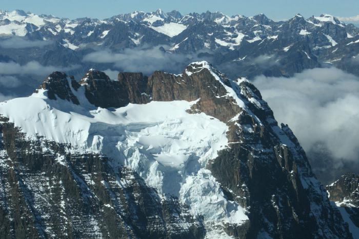
2. Transantarctic Mountains (8105 km)
The Transantarctic Mountains look quite different, which is not easy to even view from the side because of the many kilometers thickness of ice covering them. This mountain range, passing through the entire continent, divides Antarctica into eastern and western parts. It includes separate mountain systems, which are divided into smaller ridges.
The Transantarctic mountains are much older than other mountains in Antarctica, which are mostly volcanic in origin. During the formation of the West Antarctic rift located to the east, tectonic uplift led to the formation of a ridge, and this was in the early Cenozoic - about 65 million years ago. Geologists still cannot figure out the structure of these mountains. It is only known that coal seams lie in their upper layers, but at the moment no one even thinks about its extraction - firstly, it is too expensive, and secondly, the special status of Antarctica does not allow.
Although the lion's share of the mountains of the Transantarctic ridge is covered with eternal ice, there is a corner - the Dry Valleys, in which there is no ice or snow at all. This is a variant of the Antarctic desert, in which there is practically no rainfall.
3. Rocky Mountains (4830 km)
.jpg)
For the inhabitants of the United States, the Rocky Mountains have become one of the natural symbols of the country - also part of the Cordillera, but in North America. They pass through the territory of Canada and the United States. The flora and fauna of the Rocky Mountains is not inferior in diversity to the Ural Mountains. In the distant past, indigenous people have already settled in this area - the Indians, who were engaged in gathering, hunting, and equipped their settlements. With the arrival of the Europeans, people began to actively intervene in the existing ecosystem, which led to a significant impoverishment.
The Rocky Mountains have huge reserves of a wide variety of minerals, the extraction of which was often carried out in a barbaric manner. After the depletion of the deposits, abandoned mines and toxic waste were left here. But now the situation is gradually changing - the governments of both countries have begun to develop measures to eliminate the negative consequences of resource extraction, so the mountains have hope for the restoration of natural diversity.
The Rocky Mountains are extremely picturesque. People come here to fish, go downhill skiing, enjoy the views of nature. The best ski resorts in the USA are located here, national parks and reserves are organized everywhere, including the famous Yellowstone.
4. Great Dividing Range (3244 km)
.jpg)
This mountain range, made up of volcanic rocks, limestones and granites, is not very picturesque. For Australia, where it is located, it is more important as a source of minerals, rather than a tourist attraction. The mining of coal, gas, oil and gold flourishes here. On the slopes of the local mountains, there are the sources of many rivers on which dams and hydroelectric power stations are built. Although the Great Dividing Range has mainly industrial applications, the Australians also established several national parks on its territory. And the Blue Mountains, which are part of it, were included in the UNESCO World Heritage List.
It is not for nothing that the mountains are called one of the most grandiose creations of nature; they have fascinated and delighted people at all times. This is not surprising, tall ...
5. Kunlun (3000 km)
.jpg)
One of the largest mountain systems in Asia is the Kunlun Mountains located in China. They stretch from the Pamirs to the Sino-Tibetan mountains, bypassing Tibet from the north. These mountains are the source of many large rivers, including the Yurunkash (White Jade River) and Karakash (Black Jade River). The Kunlun Mountains arose about 250 million years ago (Late Triassic), when the continent of Laurasia collided with the Cimmerian Plate, which also led to the disappearance of the ancient Paleotethis Ocean.
Even in ancient times, caravan trails were laid along the sky-high passes of Kunlun, connecting China with India and Tibet. Along the northern slope of Kunlun from Dunhuang, the southern Silk Road passed, heading through the pass to the Pamir plateau. Currently, there are only three roads in these mountains, and in 2006 Kunlun was connected to Tibet by the Kunlunshankou tunnel.
Due to the lack of heat and moisture, as well as poor soil, the flora of Kunlun is scarce - mainly wild cereals and various types of wormwood grow here. In some places, at heights of 3500-4000 m, there are forests of treelike juniper and Tien Shan spruce. Of the animals, mainly rodents and ungulates are represented here, but sometimes wolves, foxes, and snow leopards are also found.
6. Appalachian Mountains (2,400 km)
.jpg)
In the east of North America, across Canada and the United States, there are the Appalachian Mountains. To the north of the Hudson and Mohawk rivers lie the Northern Appalachians, which are hilly plateaus with separate massifs, for example, Mount Washington (1916 m), on which traces of ancient glaciation are visible. The axis of the Southern Appalachians consists of parallel massifs and ridges separated by valleys.
Coal, gas, oil, titanium, and iron ore are mined here. The mountains are overgrown with coniferous, deciduous and mixed forests. They arose in the Permian period as a result of the formation of the Pangea continent.
Geomorphologically, the Appalachians are divided into two parts. The most ancient are the mountains of New England (Northern Appalachians), which have now turned into a fairly flat plateau with a height of 400-600 m, among which sparse ridges and blocky massifs rise. Later, the Southern Appalachians appeared (the era of the Hercynian folding), so they still retain a more diverse relief.
There are only 14 mountain peaks on our planet that are over 8000 meters high. Most of the peaks are located in the Himalayas and are known to everyone under the name & laqu ...
7. Himalayas (2330 km)
.jpg)
Between the Tibetan Plateau located to the north and the Indo-Gangetic Plain to the south, there is the highest mountain system of the planet - the Himalayas. They are located in 5 Asian countries. The name of the mountains has Sanskrit roots - “himalaya” is translated as “the kingdom of snows” or “gentle abode”.
There are also many minerals in the Himalayas: copper, chromium, arsenic ores, gold placers. In intermontane basins and in the foothills, reserves of brown coal, gas, oil, rock and potassium salt have been explored.
The best climbers in the world come to the Himalayas, whose cherished goal is to conquer the local eight-thousanders. There are peaks here that have not yet been conquered by man.
8. Atlas Mountains (2092 km)
.jpg)
This mountain system is located in northwest Africa, stretching from the Atlantic coast of Morocco to the coast of Tunisia through Algeria. Initially, only mountains in medieval Mauritania, which are now located in the center and western side of the Atlas Mountains, were called the Atlas Mountains. Mountains separate the Atlantic and Mediterranean coasts from the Sahara inland desert.
Different parts of the Atlas Mountains lie in different climatic zones - tropical and subtropical. The predominantly Arab population lives here. On the tops of the northern mountains, there are traces of the ancient glaciation that reached here, the Sahara ridge passes through the desert, in which there are flowering oases, rivers and salt lakes. In the west and north of the mountains, up to a height of about 800 m, the vegetation resembles typical Mediterranean forests of cork oak and evergreen shrubs. In the south and inland, the climate is arid, so only more drought-resistant grasses, wormwood and feather grass have survived here.
Seamounts, in contrast to land mountains, represent a separate uplift of the underwater bottom and are characterized by pronounced peaks or peaks ...
9. Ural Mountains (2000 km)
.jpg)
The Ural Mountains stretch from north to south of Eurasia, dividing it naturally into two continents - Europe and Asia. The beauty of the Urals is confirmed by almost all people who were lucky enough to visit there. The nature here is incredibly picturesque and diverse, which begs to be captured in pictures or paintings. The local lakes, scattered throughout the entire length of the Urals, are especially good. Every year lovers of this quiet hunt come to them to fish, and just to relax in the bosom of such a magnificent and healing nature.
Since the times of Peter the Great, the Ural Mountains have been a storeroom with inexhaustible reserves of minerals. Here, for the first time in Russia, gold was found, as well as various semi-precious stones: jasper, malachite, amethyst, emerald and many others. In the Urals, a lot of commercial timber is obtained at logging bases.
10. Altai mountains (1847 km)
.jpg)
The word "Altai" is translated from Turkic dialects as "Golden Mountains". Indeed, there are not so many places on our planet that are so abundant in natural resources, clear waters and amazing landscapes. The system of ridges included in the Altai Mountains is distributed over the territory of 4 countries: Russia, Mongolia, Kazakhstan and China. Altai nature is incredibly generous - the purest lakes, rapids mountain rivers, alpine meadows and the endless sea of coniferous forests - all this forever fascinates and is imprinted in the memory.
UNESCO has included in its World Heritage List a significant part of the Altai Mountains, called "Altai - Golden Mountains": Altai and Katunsky reserves, Ukok plateau, Belukha mountain and Teletskoye lake. There are over 300 caves here. The Altai mountains have incredibly diverse flora and fauna. On its relatively small territory, most species of Asian vegetation, as well as Kazakhstan and the European part of Russia, grow. Depending on the height of the mountains, here you can see taiga, steppe, mountain tundra, and alpine meadows.
The longest mountain range in the world is the Andean Cordillera or simply the Andes. From the language of the Incas, this short word is translated as the Copper Mountains. The length of the Andes is not comparable to any other mountains on the planet. They stretched for a record 9,000 kilometers. In addition to its incredible scale, the Andes are famous as the birthplace of plants that have radically changed the lives of people on the planet. After all, it was the Andes that became the birthplace of coca, cinchona, tobacco, tomatoes and potatoes.
The Andes begin near the Caribbean Sea and reach Tierra del Fuego. The highest peak of the mountain range is Mount Aconcagua (6962 meters). In the Andean Cordilleras there are places where the mountain range stretches for 500 kilometers in width, and the maximum width of the mountain system is 750 kilometers. The longest mountains in the world serve as the largest interoceanic watershed.

The Andes are unusually diverse and picturesque. And each country crossed by the mountain system has its own flavor. For example, in the Andes of Venezuela, deciduous forests and shrubs grow on red soils. The lower parts of the slopes from the Central to the Northwest Andes are covered with tropical and equatorial rainforests. There are ficuses, bananas, palms, cocoa trees, bamboos, and lianas. However, there are also numerous moss bogs and lifeless rocky areas. Well, everything above 4500 meters is already eternal ice and snow.

Summit of the Andes - Mount Aconcagua (6962 meters)
The fauna of the Andes is no less interesting. There are exotic alpacas, llamas, chain-tailed monkeys, as well as pudu deer, relic spectacled bears, vicuñas, sloths, blue foxes, chinchillas and hummingbirds.

One mountain is great, but it's even better if there are many mountains. It is especially pleasing to the eye when they are united in a long ridge, in which peaks alternate with valleys, small spurs, and all this is diluted with the murmur of rivers. Such beauty, stretching for several thousand kilometers, will not leave anyone indifferent. The emergence of mountain ranges is explained by the theory of relief formation. It says: ridges of valleys, mountains and hills are formed as a result of the collision of continental plates, creeping on top of each other. It is difficult to imagine the forces that are needed for such a process. Yes, it is not necessary. Better to admire the result of their activities. Especially if these are the longest mountains in the world. Let's rank them and find out where they are.
Cordillera
To begin with, I would like to clarify one important point. Many people confuse these mountains with the Andes, although these are two completely different chains formed in different eras. Some call the Andes the "Andean Cordilleras", but they have nothing to do with these mountains. Confusion also arises about their location. The Cordillera embrace North America from the south and west, creating a tight climatic barrier. For the Andes play the same role. It is interesting that these mountains practically converge at the junction of the two Americas. Therefore, they are often combined into a single mountain range, which is fundamentally wrong. It would be more correct not to confuse these giants and leave the Cordillera to North America, and the Andes to South America.
So, the Cordillera is the longest mountain in the world, with a length of just over 18,000 kilometers. They differ from their “colleagues” in a number of ways. The Cordillera are elongated exclusively in the submeridional direction, have a high percentage of high mountains, formed in five orotectonic belts of different ages, have active volcanism and high seismicity.
Sea mountains
Not everyone knows that mountains can be found not only on the ground, but also under water. Unfortunately, most of them are hidden from the sight of hikers. And they are interesting to few, because you can't ski on such mountains. Well, conquering the peaks will look pretty ridiculous. But underwater chains are not inferior in number to aboveground ones. The height of the underwater giants is difficult to determine, but the length is easy to measure.
So, the second place in the rating "The longest mountain in the world" is near the Mid-Atlantic ridge with a total length of 18,000 kilometers. It is located in the center along the contour of the American coast. This formation includes several ridges: Knipovich, Mona, Reykjanes, South and North Atlantic. Individual peaks converted to Bermuda, etc.). Among the ridges listed above, there are no particularly high, old or young ones, they are just the longest mountains on earth after the Cordillera, which is also a lot. Go ahead.

Andes
The Andes is the third longest mountain in the world, with a total length of 9,000 kilometers. With their wide front, the Andes are directed towards and in the north they go out to the Caribbean Sea. The eastern part of the border leads to the Andean ridges. By the way, ranges of different ages are located along the entire length of the mountain system. Mountain-building movements continue now, accompanied by earthquakes and volcanic processes.
The Andes is characterized by a high-mountainous relief, which determines a noticeable altitudinal zonation and the formation of significant glaciation. The huge length of the mountain system determines the difference in moisture and heat supply of its individual parts. Despite the fact that the subcontinent is mountainous, its territory has long been densely populated. The Andean peoples have mastered the high plains, intermountain valleys and hollows within the mountain system and adapted to life in such conditions. The Andes are home to the most mountainous villages, cities and arable lands. There are six physical-geographical units within the mountains. But in this article we will only talk about two: the Central Andes and Tierra del Fuego.
Central Andes
The largest part of the mountain system. Within its limits are the mountain ranges of Argentina, Chile, Bolivia and Peru. The orotectonic structure is characterized by the presence of high-altitude plateaus and a plateau - "Pun" (or "Altiplano" in Bolivia). The rigid median array, within which these plains were formed, is divided into several blocks. This is clearly visible in the cracks that have appeared due to the uplift of magma and the outpouring of lavas. As a result, there is a combination of accumulative plains in the lowlands of the relief, peneplain areas and lava plateaus. As for the climate, the Central Andes is quite arid.

Tierra del Fuego
The archipelago includes several dozen islands of various sizes. The largest of them, occupying two-thirds of the total territory, is about. The islands belong to Argentina and Chile. The western part of Tierra del Fuego continues the Andes mountain system and is highly dissected. Mountain ranges (1000-1300 meters) are separated by intermountain valleys, and some are flooded with ocean waters - straits, fjords. The highest point (2469 meters) is located on the Big Island. Ancient glacial relief prevails. There are a lot of lakes, dammed by moraines.
In most of the archipelago, temperate prevails. In the western part, abundant rainfall (drizzling rains) up to 3000 mm falls throughout the year. In the east, precipitation is less - up to 500 mm. Summers are cool, and winters are relatively warm (1-5 ° C). Tourists who have visited Tierra del Fuego declare that summer there is like in the tundra, and winter is similar to the subtropics (in terms of temperatures). With the rise in the mountains, the temperature drops sharply and already at around 500 meters reaches a negative value.

In Antarctica, there is not only ice, snow and penguins, but also mountains. And they are quite long. All Antarctica is crossed by a huge ridge, dividing it into Western and Eastern. Ranked last in the "World's Longest Mountain" rating, it stretches over 3,500 kilometers. The ridge was discovered back in 1908 by Captain Ross. In subsequent years, it was repeatedly crossed by research expeditions, but most of it still remains unexplored. Fortunately, now there is satellite imagery, which allows, if not to feel the ridge, then at least look at it.
The length of the Andes - 9000 km
Andes or Andean cordillera, in the language of the Incas - copper mountains. They form the longest mountain range in the world. Their length is 9000 km - from the Caribbean Sea to Tierra del Fuego. The highest mountain in this mountain range is Aconkagau (6962 m). There are places where the Andes are 500 km wide, and the maximum width of the longest mountains in the world is 750 km (Central Andes, Andean highlands). Most of the Andes is occupied by the Pune plateau. There is a very high snow line, which reaches 6500 m, and the average height of the mountains is 4000 m.
The Andes are relatively young mountains; the mountain building process ended many millions of years ago. The origin began in the Precambrian and Paleozoic periods. Then, on the site of the endless ocean, areas of land were just beginning to emerge. Throughout the entire time, the area where the present Andes are located was either sea or land.
Formation of the Andes

The formation of the mountain range ended with the uplift of rocks, as a result of which huge folds of stone moved to a very great height. This process continues to this day. Volcanic eruptions and earthquakes occur in the Andes.
The longest mountains in the world are also the largest interoceanic watershed. In the Andes, the Amazon and its tributaries originate, as well as the tributaries of other major rivers in South America - Paraguay, Orinoco, Parana. The Andes serve as a climatic barrier for the mainland, that is, they isolate the land from the west from the influence of the Atlantic Ocean, from the east - from the Pacific Ocean.
Climate and relief of the Andes

The Andes lie in 6 climatic zones: northern and southern subequatorial, southern tropical, equatorial, subtropical temperate. On the western slopes of the mountains, up to 10 thousand millimeters of precipitation falls per year. As a result of their length, the landscape parts differ significantly from each other.
In terms of relief, the Andes are divided into three regions: central, northern, southern. The Caribbean Andes and the Ecuadorian Andes, the Northwest Andes belong to the North Andes. The main Cordillera are separated by the valleys of the Magdalena and Cauca rivers. There are many volcanoes in this valley. These are Huila - 5750 m, Ruiz - 5400 m, and the current Kumbal - 4890 m.
Volcanoes of the Andes

The Ecuadorian Andes includes a high volcanic chain with the highest volcanoes Chimborazo - 6267 m and Cotopaxi - 58967 m. They stretch through seven states of South America: Bolivia, Ecuador, Colombia, Peru, Venezuela, Argentina, Chile. The Central Andes include the Peruvian Andes. The highest point is Mount Huascaran - 6768.
The Copper Mountains - this is what the Incas call these the longest mountains in the world. We are talking about the Andean Cordilleras, known to us as the Andes. This mountain range is not comparable in length to any of the existing ones on our planet. The length of the Andes is about 9 thousand km. They originate from the Caribbean Sea and reach Tierra del Fuego.
Width and height of the Andes
Aconcagua (pictured below) is the highest peak in the Andean Cordilleras. The height of the Andes at this point is 6962 meters. Aconcagua is located in Argentina. What are the prevailing ones have a number of large peaks. Among them it should be noted Mount Ritakuva (5493 meters), El Libertador (6720 meters), Huascaran (6768 meters), Mercedario (6770 m), etc. There are areas where mountains reach 500 km in width. As for their maximum width, it is about 750 km. The main part of them is occupied by the Pune plateau, which has a very high snow line, which reaches 6500 m.The average height of the Andes is about 4000 m.

Age of the Andes and their formation
According to experts, these mountains are quite young. The mountain building process was completed here several million years ago. As early as the Precambrian period, the fossil record began. Land areas then began to emerge on the site of the endless ocean. The area where the modern Andean Cordilleras are located for a long time was either sea or land, and the height of the Andes changed significantly. The mountain range completed its formation after the uplift of rocks. Huge folds, consisting of stone, as a result of this process, moved to an impressive height. By the way, this process is not over. It continues in our time. Volcanic eruptions and earthquakes sometimes occur in the Andes.
Rivers originating in the Andes
The longest mountains on our planet are also considered the largest interoceanic watershed. The famous Amazon originates precisely in the Andean Cordilleras, as well as its tributaries. It should also be noted that tributaries of the large rivers of the states of Paraguay, Orinoco and Parana begin in the Andes. For the mainland, the mountains are a climatic barrier, that is, they shield the land from the west from the influence of the Atlantic Ocean, and from the east from the influence of the Pacific Ocean.
Relief
The Andes are long, so it is not surprising that they are located in six climatic zones. In contrast to the southern slopes, the amount of precipitation is high on the western slopes. It reaches 10 thousand mm per year. Consequently, not only the height of the Andes varies significantly, but also their landscape.
The Andean Cordillera are divided into 3 regions in terms of relief: Central, Northern and Southern Andes. The main Cordillera are separated by depressions such as the Magdalena and Cauca. There are many volcanoes here. One of them, Huila, reaches 5750 m. Another, Ruiz, rises to 5400 m. Kumbal, which is now active, reaches a height of 4890 m. The Ecuadorian Andes, belonging to the North, include a volcanic chain marked by the highest volcanoes. Chimborazo alone is worth something - it rises to 6267 m. The height of Cotopaxi is not much less - 5896 m. The highest point of the Ecuadorian Andes is Huascaran - 6769 m is the absolute height of the mountain. The South Andes are divided into Chilean-Argentine and Patagonian. The highest points in this part are Tupungato (about 6800 m) and Medsedario (6770 m). The snow line reaches six thousand meters here.
Llullaillaco volcano

It is a very interesting active volcano located on the border of Argentina and Chile. It belongs to the Peruvian Andes (Western Cordillera ridge). This volcano is located in the Atacama Desert, which is one of the driest places on our planet. The absolute height of the Andes at the point is 6739 m. It is the highest of all the existing ones. In the area of this volcano, the Andes mountains are very peculiar. Its relative height reaches 2.5 km. On the western slope of the volcano, the snow line exceeds 6.5 thousand m, which is its highest position on the planet.
Atacama Desert

In this unusual place, there are areas that have never rained. The Atacama Desert is the driest place on Earth. The fact is that the rains cannot overcome so they fall on the other side of the mountains. The sands in this desert extend to the very tropics for thousands of kilometers. The cold fog rising by the sea is the only source of moisture for native plants.
San Rafael glacier
Another interesting place that I would like to talk about is the San Rafael Glacier. It should be noted that in the south of the Alpine Cordilleras, where it is located, it is very cold. At one time, this very much surprised the pioneers, since the south of France and Venice lie at the same latitude in the northern hemisphere, and here they discovered the San Rafael glacier. It moves, at the same time constricting the slopes of the mountains, the peaks of which become sharper and steeper over time. Only in 1962 was its source discovered. A giant ice sheet cools the entire region.
Vegetation

The Andes are a unique place on our planet, and not only because of the impressive width and height of the mountains. The Andes are extremely picturesque. In different places, they have their own flavor. In the Andes of Venezuela, for example, shrubs and deciduous forests grow on red soils. Equatorial and humid rainforests cover the lower slopes from the Northwest Andes to the Central Andes. Bananas, ficuses, cocoa trees, palms, vines and bamboos are found here. However, there are rocky lifeless spaces, and many. In places where the average height of the Andes exceeds 4500 m, there is an area of eternal ice and snow. The Andean Cordilleras are known as the birthplace of coca, tomatoes, tobacco and potatoes.
Animal world
The fauna of these mountains is no less interesting. Llamas, alpacas, pudu deer, vicuñas, spectacled bears, blue foxes, sloths, hummingbirds, chinchillas live here. The inhabitants of our country can find all these animals only in zoos.
One of the features of the Andes is a wide variety of amphibian species (about 900). The mountains are home to about 600 species of mammals, as well as about two thousand species of birds. The variety of freshwater fish is also great. There are about 400 species of them in local rivers.
Tourism and locals
The Andean Cordilleras, apart from remote and rugged areas, are not an untouched corner of nature. Local residents cultivate almost every piece of land here. However, the road to the Andes for most tourists means a "departure" from modernity. For centuries, these places have maintained a constant way of life, which allows tourists to feel like they are in the past.

Travelers can follow the ancient Indian trails, where, however, sometimes it is necessary to stop to let the herd of guanacos, sheep or goats pass ahead. No matter how many times you have already visited these local places are always mesmerizing. Meetings with locals are also unforgettable. Their way of life is far from what we are used to. The huts in these areas are built of raw bricks. Local residents often do without electricity. In order to get water, they go to the nearest stream.
Hiking in the mountains is not mountaineering in the usual sense of the word. Rather, these are walks along steep paths. However, they should be performed only by absolutely healthy and well-trained people with special equipment.