
Mekong Delta. Mekong Delta Road from Ho Chi Minh City to the Mekong River
Mekong Delta (Ho Chi Minh City, Vietnam) - detailed description, location, reviews, photos and videos.
- Hot tours Worldwide
Previous photo Next photo
The magnificent Mekong Delta is the place where you most fully experience the exoticism of Vietnamese life. Broken into a thousand branches before flowing into the sea, the Mekong for Vietnam is about the same as the Nile for Egypt - the cradle of civilization, the breadwinner of numerous coastal inhabitants (about 17 million) and one of the most powerful magnets for tourists. Excursions to the Mekong Delta are offered from one to three days, and the number of impressions received here would be enough, perhaps, for a week of leisurely swimming in a junk through the branches and channels.
A bit of geography and history
The Mekong River Delta occupies the very "tail" of Vietnam - a vast region on the southwestern tip of the country, with an area of about 39 thousand square meters. km, most of which is indented by sleeves and channels. To the east is the city of Ho Chi Minh, so excursions to the Mekong Delta are extremely popular among both tourists and residents of the capital. Among other things, the region traditionally includes Phu Quoc island, the recreation infrastructure on which is developed for a solid five plus - therefore, excursions to the delta are offered of different duration and intensity.
The history of the settlement of the Mekong Delta began in the prehistoric period - archaeological finds indicate that a developed culture existed here already in the 1st century BC. Over the course of subsequent history, the delta has repeatedly become the subject of disputes between neighboring states - Laos and Cambodia, however, as a result, it remained in the possession of Vietnam, becoming a popular place for excursions.
Mekong Delta
Excursions to the Mekong Delta
Excursions to the Mekong Delta - mandatory item cultural program of tourists in Vietnam. Its duration is from 1 to 3 days, depending on whether visits to floating markets and holidays on Phu Quoc Island are included in the program.
Way from Ho Chi Minh to starting point for a boat tour takes about 2.5 hours. Then the tourists transfer to the junk and spend the rest of the time on it, sailing from island to island, each of which has some kind of attraction or interesting pastime.
The tour begins with a walk along the banks of the Mekong, where you can see the houses local residents(many of which are floating), marinas with boats and coastal markets. Further, tourists land on one of the islands, where a factory for the production of coconut candies is located. Here you can watch them being made and buy a box to your liking. Broken on another island natural Park where you can walk or ride bicycles, see plantations of exotic fruits and taste unfamiliar fruits. This is followed by a boat trip through the narrow inland channels of the Mekong, where there are no islands or coastal settlements - only tropical nature. The tour continues on one of the residential islands, where you can visit a traditional Vietnamese village with authentic dwellings, walk around the apiary and taste honey, buy handicrafts and souvenirs. There is also a factory for the production of candied fruits. After lunch, tourists return to Ho Chi Minh City or spend the night in one of the local hotels - in order to continue the tour of the colorful floating markets in the morning or complete their impressions with a vacation in Fukuoka.
The Mekong is located in the southeastern part of Asia and flows through the territory of 4 states: China, Laos, Cambodia, Vietnam. On the right bank of the river are also state borders Myanmar (Burma) and Thailand. Thus, 6 states are inextricably linked with the river.
The Mekong River originates in the Tibetan Plateau. This is the Tangla Ridge. It represents an endless series of snowy mountains and stretches for 600 km. The maximum height of the ridge is more than 6 km. At an altitude of 5.5 km, mountain streams begin their journey, gradually turning into turbulent mountain rivers. Two such rivers, breaking through deep canyons, form the Mekong. They are called Dze-Chu and Dza-Chu. Thus, the source of the Mekong River is located in the southern part of the Tibetan Plateau at an altitude of about 5 km above sea level.
In its upper and middle reaches, the Mekong watercourse crosses gorges and abounds in rapids. They are especially evident at low water levels. This is a huge path to Cambodia, where the river enters the Cambodian plain. Here, near the small Lao town of Khon, there is a waterfall of the same name. This, in fact, is not a waterfall in the truest sense of the word, but a cascade of rapids. At a distance of several kilometers, their height decreases by 21 meters. Water consumption is huge and averages 9 thousand cubic meters. meters per day. In high water, it can reach 38 thousand cubic meters. meters per day. This is the maximum and officially registered value. Khon waterfall is very beautiful. It once again emphasizes the mighty power of nature. But it has one significant drawback. Bubbling and foaming waters interfere with navigation. Which is a big disadvantage from an economic point of view.
Rapids with a waterfall do not end. They stretch all the way to the Cambodian city of Kratie. Its population is 20 thousand people and there is a river port. That is, a water connection has been established with the capital of Cambodia. She is the city of Phnom Penh with a population of over 1.5 million people.
Below the administrative center, the Mekong River spills to its full extent and forms a huge delta with an area of approximately equal to 70 thousand square meters. km. In this case, the channel is divided into left and right branches. Between them are smaller sleeves and an uncountable number of ducts. This area is swampy, covered with shrubs, and it would be more correct to call it a huge mangrove swamp. 17 million Vietnamese live in the delta region, since most of its area falls on Vietnam. The mighty water stream ends its journey in the South China Sea. The delta protrudes far into the sea, and its length from edge to edge is 600 km.
Eating by the river upstream ice and snow. Rainy in the middle and lower reaches. Of great importance are also lakes and tributaries, which give a large number of additional water. Most large lake located in Cambodia and is called Tonle Sap. Its area is 2.7 thousand square meters. km. The depth does not exceed 1 meter. The lake is connected to the great river of Indochina by a channel that bears the same name as the reservoir.
During the rainy season, water comes from the Mekong, and the depth of the lake reaches 9 meters. And in the dry season, on the contrary, Tonle Sap becomes a source of food. Water enters the river and maintains its flow at the proper level. That is, these two water sources live according to the law of communicating vessels. The Mun River, which flows through Thailand, is also considered a large tributary. Its length is 673 km, and the annual flow reaches 21 thousand cubic meters. meters.
The Mekong River is inextricably linked to shipping. Ocean liners rise up the river to Phnom Penh. It is 350 km from the mouth. The total length suitable for navigation is 700 km. In high water, when the river level rises by 10-15 meters, this value increases to 1600 km.
On the banks of the great river of Indochina are cities such as Luang Prabang with a population of 50 thousand people, as well as Vientiane with a population of 750 thousand people. These are the cities of Laos. And the second is its capital. Of the Cambodian cities, one can name Styngtraeng with a population of 112 thousand people, Kratie and, of course, Phnom Penh. In Vietnam, the city of Can Tho should be specified. Its population reaches 1 million 187 thousand people. Significantly inferior to him is the city of Mytho. Only 215 thousand inhabitants will live in it. And, of course, such a city as Benche, accommodating 144 thousand people.
The Mekong River has a huge energy potential. It can produce tens of millions of kW. But here it all comes down to a mismatch of interests. different countries. The Chinese are ready to build both 5 and 10 hydroelectric power stations, but the inhabitants of Laos and Cambodia oppose this. After all, dams will block the river, and, consequently, the water level will decrease, thanks to which the soil receives the necessary nutrition during floods and gives people rice and other crops.
Chinese experts say that the level of the river will not fall, since it receives the main food from rains and tributaries. However, the Laotians and Cambodians are not so optimistic. They point out that during a drought, the Mekong River is fed precisely by glacial and snowy waters flowing through the lands of China. So there is no agreement and understanding between the countries located in the basin of the great river of Indochina.
The Mekong River is classified as a long and major rivers in the world. The American gazetteer claims that the length of the Mekong is 4350 kilometers. Some sources say that the river ranks eleventh on the planet, while others say it ranks twelfth. Some rivers are distinguished by disputed sources, so disagreements arose between geographers. The mighty water stream is located in the southeast of Asia, and also flows through four states, these are: Vietnam, Cambodia, Laos and China. On its right bank are the state borders of Thailand and Myanmar. Therefore, it turned out that six countries are firmly connected with this river. Where is .
The Mekong flows in the Tibetan Plateau we are talking about the Tangla range, it is an endless series of snowy mountains, six hundred kilometers long. Two mountain rivers start their journey here, which make their way through deep canyons, becoming the Mekong River. For this reason, the source of the Mekong River is located in the south of the Tibetan Plateau. In the middle and upper reaches, water abounds in rapids and crosses gorges. They are often seen during low level water. In fact, this is a long way to Cambodia, here the river enters the Cambodian plain. What does it look like.
Note that next to the small Lao town of Khon, there is a waterfall of the same name. Although you can’t call it a waterfall, because it is a cascade of rapids. You can see a large number of small waterfalls that flow down. The water consumption is about nine thousand meters per day. The Mekong River is fed by snow and glaciers, and rain is fed in the lower and middle reaches. Lakes and tributaries have great importance for the river, they provide the necessary additional volume of water.
Shipping on the Mekong River
During the rains from the Mekong, water enters the Tonle Sap Lake, its depth is nine meters. Interestingly, this lake replenishes the Mekong during the dry season. They have such mutual support. The river, which flows into the river from the lake, maintains the water flow at the proper level. flows through Thailand major tributary Mekong - Mun River with a length of 673 kilometers. The Mekong River is inextricably linked with shipping. Ocean liners follow up the river to Phnom Penh. Suitable for navigation is a section of the river, with a length of seven hundred kilometers. During the flood period, the water level in the river rises to fifteen meters, and then the length of the navigable route increases to 1600 kilometers.
On the banks of the Mekong are such interesting cities Like: Vientiane, Luang Prabang. They belong to the Lao cities. Among the Cambodian cities, it is worth highlighting: Stingtraeng, Phnom Penh and Kratie. The city of Can Tho is located in Vietnam, where over a million people live. Less people lives in the city of My Tho, and even less in the city of Ben Tre. It has a huge energy potential mighty river Mekong, because it can provide tens of millions of kilowatts. Different countries do not have the same interests in this matter. For example, the Chinese are ready to create from five to ten hydroelectric power plants, but this is opposed by the inhabitants of Cambodia and Laos.
If the river is blocked by dams, this will lead to a decrease in the water level. It should be noted that the soil receives important nutrition precisely due to spills, because rice and some other agricultural crops are grown here. Chinese experts claim that this will not affect the level of the river. After all, the river is mainly fed by tributaries and rains. But Cambodians and Laotians are not so optimistic.
A floating trading boat on the Mekong in the Chaudok region. Photo (photo credit): Natalie Belikova, FiveStepsPhotoblog
In the region, the tourist infrastructure (outside of organized tours to the Delta) is rather poorly developed, but you can travel between the cities of the Delta by regular buses. Travelers in the outback of the Delta are very friendly.
Cities of the Mekong Delta
The main cities of the Mekong Delta, which are included in tourist routes independent travelers are Can Tho and Chau Doc. The town of My Tho, located near Ho Chi Minh City, is usually included in the programs of organized tours from Ho Chi Minh City. Vinh Long and surroundings is the least developed region from a tourist point of view, it is preferred by eco-tourists and cyclists. Cai Be - a place where you can find good options lodging in the Mekong Delta.
Can Tho
- most Big city on the Mekong, business, trade, transport, cultural and tourist centre Mekong Delta. Can Tho is a bustling, vibrant city with picturesque views of the river and hundreds of opportunities to enjoy your stay here. Colorful floating markets, bird gardens, countless canals, picturesque rice fields and fruit plantations. They say about Can Tho in Vietnam quite poetically: “White rice, pure water everyone who gets here wants to stay here.” If we add to all these joys a fairly decent selection of accommodation, it becomes clear why travelers most often choose Can Tho as the main point for exploring the Mekong Delta.
Floating market in Can Tho. Photo credit: Uncornered Market, Flickr
Mitho
This tiny town on the Mekong is located just outside of Saigon (Ho Chi Minh City) and is one of the most popular starting points for tours of the great river organized by Ho Chi Minh City travel agencies and local tourist offices. The classic Mekong tour from My Tho includes visiting the islands and local attractions such as a coconut factory, boating on the river, visiting the islands and fruit tasting.
Independent travelers choose My Tho as a base for exploring the Mekong quite rarely, since the tourist business in My Tho is still focused on organized tourism, and this invariably affects prices. But, in principle, if you stop in My Tho for the night to ride along the river, explore the nearby islands and visit the floating one early in the morning, the town can be a pleasant surprise. If you come here, don't forget to try the famous local rice noodle soup called Mi Tho.
Hotels, Guest Houses: My Tho
How to get there: by bus from Ho Chi Minh City and most cities in the Mekong Delta

Mitho. Photo credit: Aaron Geddes, Flickr
Vinh Long
This small town, located on the banks of the Mekong River, is one of those wonderful places where you can come face to face with authentic Vietnam. Vinh Long does not have fancy hotels and developed tourist infrastructure, but here you can stay overnight in the house of local residents on An Binh island, rent a boat to visit the local floating market and explore the area on a bicycle.
– wonderful place, where from morning to evening you can watch everyday scenes from life on the great river, feast on local fruits, vegetables and fresh Mekong fish dishes and enjoy the hospitality of local residents.
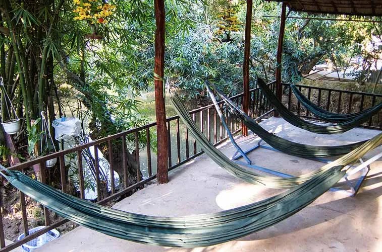
Hammocks in a guest house, Vinh Long. Photo credit: Lindsay Buckley, Flickr
On the streets of Vinh Long. Photo credit: Ralph Grizzle, Flickr
Kaibe
- a tiny sleepy town in the Mekong Delta, in the vicinity of which there are several comfortable lodges - great option for those who want to get to know the Mekong Delta from the inside, but are not ready to deny themselves comfort. Lodges usually help their guests with organized or private transfers from Ho Chi Minh City, bike rentals and Mekong tour arrangements.
In contact with
Length - about 4500 km, basin area - 810 thousand km².
Geography
The origins are in the Tangla Range in the Tibetan Plateau. The upstream is called Dza-Chu(Chinese exercise 扎曲, pinyin: Záqū, Zaqiu), on average (in China) - lancangjiang.
It flows into the South China Sea, forming a delta. Main tributaries: on the right - Mun, Tonle Sap; left - San.
松岡明芳 , CC BY-SA 3.0In the upper and middle reaches, the Mekong flows mainly along the bottom of deep gorges and has a rapids channel. At the exit of the Mekong to the Cambodian plain, there is one of the largest, widest, waterfalls in the world - Khon (about 21 m high). The last rapids are near the city of Kratie, in Cambodia.
Below the city of Phnom Penh, the Mekong Delta begins (an area of \u200b\u200babout 70,000 km²), where the Mekong channel is divided into two large branches connected by numerous channels. About ¾ of the total flow passes along the main, left arm, called Tonletom.
The Mekong Delta is pushed out into the sea in the form of an arc with a total length along the coast of about 600 km. Abundant solid runoff causes the delta to grow by 80-100 m per year. The delta is swampy and in many places covered with mangroves.
 Teijo Hakala, CC BY-SA 2.0
 The food is mainly rain, in the upper reaches it is also snowy and partly glacial. Summer-autumn flood. In the middle reaches, the maximum water level is usually noted in August, in the lower reaches - in October; the lowest flow occurs in April.
The range of water level fluctuations in the mountains reaches 10-15 m, on the Cambodian plain and in the delta - up to 10 m. The average annual water flow in the middle reaches, near Vientiane, is 4.6 thousand m³ / s, the largest is about 21 thousand m³ / s, in the lower reaches (near the city of Kratieh) - 14.8 and 33 thousand m³ / s, respectively (in some years - up to 67 thousand m³ / s). The Mekong freezes only in the upper reaches for 1-2 months; carries out an average of about 1.5 km³ of sediment per year.
 Allie_Caulfield , CC BY 2.0
 Lake Tonle Sap, connected to the Mekong by a tributary of the same name, has a great regulating influence on the runoff.
During the wet season (June-November), the lake is replenished with the waters of the Mekong, in the dry season (November-June), the water level in the Mekong becomes lower than in the lake, and there is an intensive discharge of lake water into the Mekong channel, and vast fertile silt fertilized by this time is released. arrays of agricultural land.
The waters of the lower Mekong are used for irrigation. Wide floods of the river contribute to rice cultivation. The huge hydropower resources of the Mekong (about 75 million kW) are almost not used.
 Doron, GNU 1.2
 The rivers and lakes of the Mekong basin are rich in fish (mainly from the carp family), a lot of waterfowl, preserved river dolphins, crocodiles, predominantly in Cambodia.
The Mekong is navigable for 700 km (in high water - for 1600 km, to the city of Vientiane). Sea vessels rise to Phnom Penh (350 km). However, the river is very unstable, its course changes all the time and shallows appear.
On the Mekong there are cities such as Jinghong (China), Luang Prabang, Vientiane, Pakse, Savannakhet (Laos), Nong Khai, Mukdahan (Thailand), Stung Traeng, Kratie, Phnom Penh (Cambodia), Can Tho, My Tho, Ben Tre (Vietnam).
Mekong Delta
The Mekong Delta is one of the largest deltas in the world. Located in Vietnam.
On the territory of the delta there is the economic zone of the same name of Vietnam (Vietnamese Đồng bằng sông Cửu Long, literally “Delta of the Nine Dragons” - according to the number of branches into which the river is divided in the delta), whose area is 40,548.2 km². The Mekong Delta region, centered on Can Tho, is one of the most densely populated regions in the country.
If we consider the delta as a modern region of the country, then this region begins west of Ho Chi Minh City, from the province of Longan, and extends to the very south of the country, including 12 provinces and the city of Can Tho, with the southernmost point on Cape Ca Mau.
In the 21st century, the Mekong Delta region is under the threat of flooding due to climate change (rising ocean levels and associated land landslides).
Photo gallery


![]()


Helpful information
Mekong
viet. "River of the Nine Dragons"
translated from Lao - "Mother of the waters of the Ganges"
Story
The first settlements on the Mekong date back to 2100 BC. e. The first state in this area was the kingdom of Bapnom. Chenla and Kambujadesh (Khmer Empire) became his successors.
The first European in these parts was the Portuguese Antonio de Faria (port. Antonio de Faria) in 1540. At that time, European interest in this region was sporadic - only a few trade and religious representations were founded.
In the middle of the 19th century, the region fell into the zone of French interests - in 1861 Saigon was captured, and in 1863 a protectorate was established over Cambodia.
The first serious expedition to explore the Mekong took place in 1866-1868 under the leadership of Ernest Dudar de Lagre and Francis Garnier. They went from the mouth to Yunnan and found that navigation along the Mekong was impossible because of the rapids and waterfalls in the regions of the Cambodian province of Kratie and the Lao Champatsak (Khon Falls). The origins of the Mekong were explored in 1900 by P.K. Kozlov.
From the 1890s, France extended its control to Laos as well, forming French Indochina. After the Indochinese War, the Mekong began to belong to independent states into which French Indochina broke up.